By Suraj Karowa and Mary Gilbert/ANW
December 14, 2025 – Seattle, WA

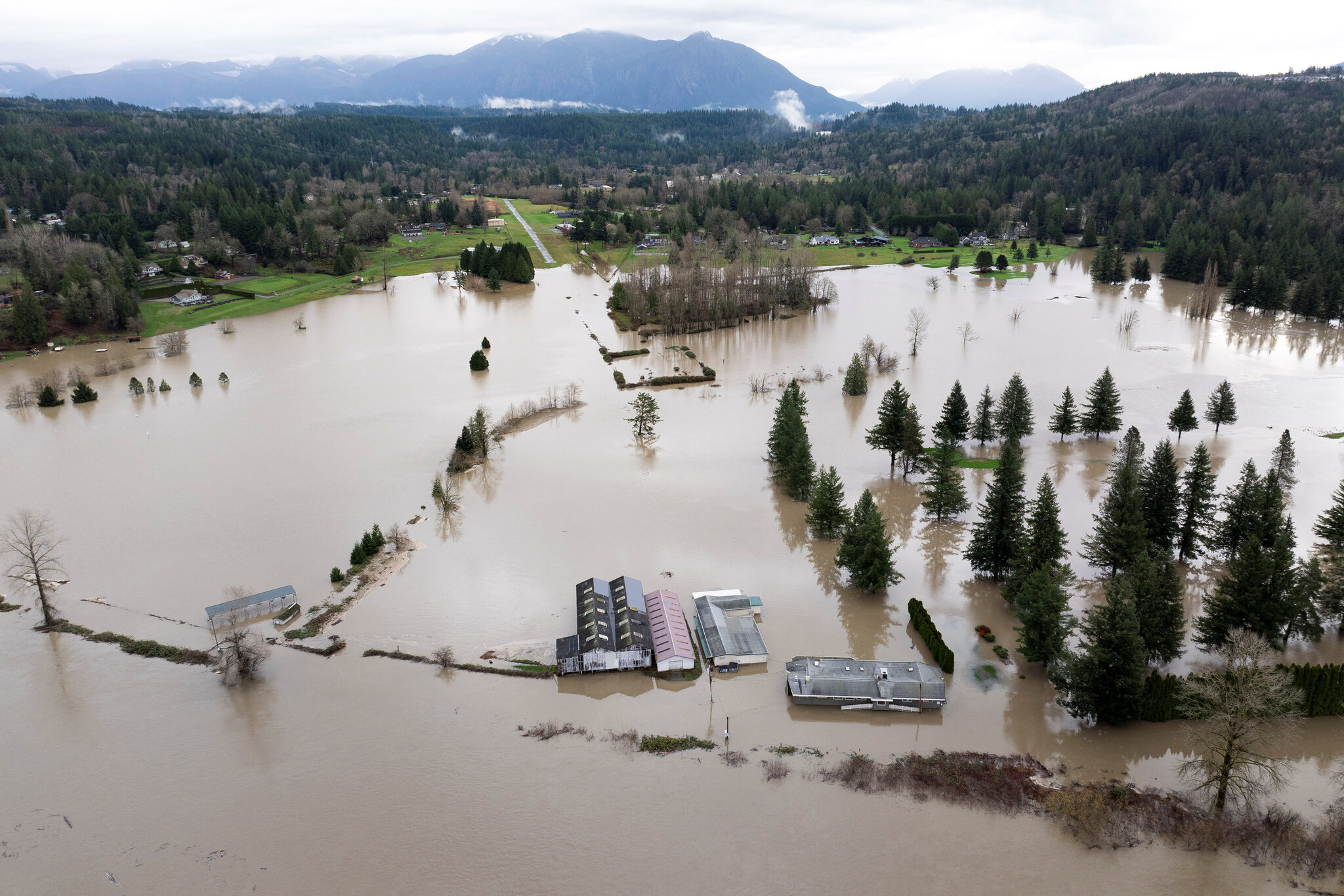
An aerial view of homes surrounded by floodwaters in Snohomish, Washington, on Thursday, December 11.
In the shadow of snow-capped Cascades, the Pacific Northwest is caught in a perilous cycle of deluge and dread.
Just as floodwaters begin to recede from a historic atmospheric river that submerged communities and shattered records, meteorologists warn of a double-barreled assault: two more potent storms barreling in next week.
Western Washington, still reeling from waist-deep inundations and emergency evacuations, braces for what could be weeks of instability, complicating recovery efforts amid the holiday rush.
The initial onslaught, peaking on December 11, was nothing short of biblical.

Rescue personnel evacuate Ivan and Fabiola Alvarez, who were stranded in their home in Snohomish, Washington, on December 11.
Torrential rains, fueled by a Category 5 atmospheric river—the strongest on record for the region—unleashed chaos across 11 counties.
Rivers like the Skagit and Cedar swelled to unprecedented heights, eclipsing benchmarks set in the infamous 1990 floods.
In Sumas, a border town near Canada, waters surged 15 feet deep, stranding residents atop vehicles and rooftops.
The U.S. Coast Guard executed daring helicopter rescues, plucking dozens from peril as muddy torrents engulfed homes and farmlands.

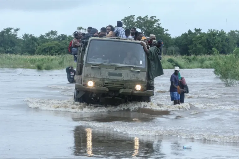
Severe flooding in Sumas, Washington left much of the area underwater.
Governor Bob Ferguson, surveying the wreckage Friday, called it “truly historic.” “This is something the people of the state of Washington have not faced before,” he declared during a somber press conference in Olympia.
“Rivers are experiencing levels of flooding we haven’t seen in generations.” Over 40,000 evacuations were ordered statewide, with tens of thousands more under advisory.
In King County alone, emergency crews fielded dozens of calls, including heart-stopping lifts from treetops in Snohomish, where couples like Ivan and Fabiola Alvarez clung to their kitchen table as waters rose.

Flood damage in Stehekin, Washington caused debris slides over burn scars, leaving isolated residents without power and for some, even water.
Whatcom County tallied over 40 rescues, at least 20 involving swift-water operations. Burlington, a quiet mill town, awoke to pandemonium Friday morning: Floods breached levees overnight, prompting a citywide evacuation.
The National Guard pounded on doors in the pre-dawn chill, herding 1,000 residents to higher ground. Hours later, the order lifted partially, but the governor cautioned against complacency. “The situation is extremely unpredictable,” Ferguson said.
“We saw that in Burlington last night—folks fleeing in a really dire situation.”
Travel ground to a halt as mudslides and washouts shuttered more than 20 highways, including a 50-mile swath of U.S. Route 2, the state’s vital east-west artery. Detours? Scarce.
The Washington State Department of Transportation reported gridlock stretching for miles, stranding holiday travelers and supply chains alike.

It will take “months” to help Stehekin, Washington recover from the damage caused by the floods, according to Chelan County Emergency Management.
King County Executive Girmay Zahilay echoed the gravity: “We are not out of the woods yet. This is not a routine storm event.
It’s historic flooding that has put lives, businesses, and critical infrastructure at risk all over our region.”
Yet, in this tableau of turmoil, human resilience flickers. In remote Stehekin Valley—accessible only by boat or floatplane—evacuation orders took effect Saturday as skies cleared briefly.
Perched 50 miles up Lake Chelan, this enclave of 75 souls grapples with isolation amplified by nature’s fury. Debris flows, triggered over burn scars from the 2024 Pioneer Fire, have severed roads, toppled power lines, and choked boat docks.
Three hamlets up-valley are marooned, their access buried under tons of mud and rock.
Chelan County Emergency Management Sgt. Jason Reinfeld painted a stark picture to reporters. “When the storm came through, it just loosened all that up,” he said.
“Slides blocked large portions of the roadway, and floodwaters sent debris flows that isolated the community.”
Power outages plague most households; some lack even well water. Utility crews, battling blocked paths, estimate “months” for full restoration.
“Clearing access is a problem,” Reinfeld added. “It’s going to take quite a while to recover—much harder in wintertime.”
Stehekin’s denizens, forged by frontier solitude, refuse to yield. Two self-sufficient clusters—hunters, homesteaders—boast stockpiles to weather the season.
“They’re well-equipped, able to sustain themselves even through winter if needed,” Reinfeld noted.
A third, fuel-starved group awaits sheriff’s airlifts of water pallets Saturday. Jenifer Byquist, a local photographer, shared haunting images: splintered docks, silt-choked creeks, homes half-submerged. “We’re resilient,” she told CNN affiliates. “But this holiday? It’s survival mode.”
State Emergency Management Director Robert Ezelle urged caution. “The situation is still fluid and dynamic,” he warned. “Don’t rush back—rivers won’t crest safely for days, maybe weeks.”
General Gent Welsh of the Washington National Guard concurred, his voice heavy with empathy.
“If you’ve been displaced, my deepest sympathies this holiday season.
But this is a long haul.” Officials lambasted vigilantes flouting closures: “Ignoring alerts endangers you and rescuers,” Welsh said.
Mercifully, the respite is real—for now. Saturday’s skies held, allowing pumps to hum and roads to dry. But the Weather Prediction Center’s crystal ball is cloudy with menace.
Light drizzle teases western Washington Sunday, a mere prelude to Monday’s headliner: A Level 4 atmospheric river, “strong” on the five-tier scale, slamming the Puget Sound with inches of rain.
Oregon’s coast catches the spillover, while a Level 1 flood risk tinges far northwestern California.
“Multiple days of continued rain next week could lead to additional significant impacts,” the WPC cautioned Thursday, eyeing moderate-to-major flooding redux.
The Snohomish and Skagit, barely dipping below major stage over the weekend, risk rapid resurgence.
Tuesday offers a gasp—easing showers—before Wednesday’s broader barrage: Rain from Washington to Northern California’s redwoods, laced with high-elevation snow in the Cascades and northern Rockies.
Forecasts blur beyond midweek, but models hint at lingering storminess. Soaked soils, reluctant to swallow more, prime the pump for flash floods and slides.
“Anyone in the Pacific Northwest and Northern California can’t let their guard down,” said Meteorologist Mary Gilbert, co-author of this forecast.
As federal aid trickles in—FEMA teams assessing damages Saturday—communities pivot to perseverance. In flooded basements and sandbagged streets, neighbors swap generators and stories.
The deluge has drowned dreams: Lost livestock, ruined harvests, shuttered shops. Yet, in evacuation centers festooned with tinsel, volunteers serve hot cocoa, a defiant nod to yuletide spirit.
This saga underscores a warming world’s wrath. Atmospheric rivers, once rare winter wonders, now lash with feral frequency, supercharged by climate change.
The Pioneer Fire’s legacy—barren slopes prone to runoff—amplifies the peril, a reminder that yesterday’s blazes seed tomorrow’s floods.
For now, Washington holds its breath. The rains may pause, but the rivers remember.
In Stehekin and beyond, the Northwest endures—not just weathering the storm, but forging ahead through its endless gray.
Discover more from AMERICA NEWS WORLD
Subscribe to get the latest posts sent to your email.


Leave a Reply