By_Suraj Karowa/ANW , November 11, 2025

CHICAGO — An unrelenting Arctic air mass has transformed the Midwest into a premature winter battlefield, dumping over a foot of snow across the Great Lakes region and spawning lake-effect fury that has crippled travel and shattered temperature records from Florida to the Northeast.
As of Monday morning, the cold front—described by meteorologists as a “full-scale polar plunge”—has already claimed headlines with historic snowfalls and bone-chilling lows, but relief is in sight as warmer air begins to nudge in by midweek.
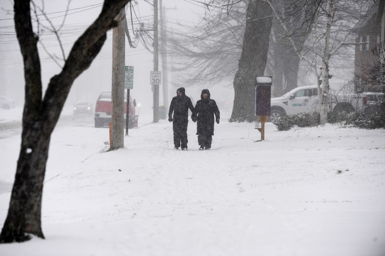
The epicenter of the storm lies along the shores of Lake Michigan, where narrow bands of lake-effect snow have carved a path of devastation. In Chicagoland, overnight accumulations escalated into a whiteout spectacle, complete with thunder snow and gale-force winds that howled through the night.

While downtown Chicago dodged the worst, dodging forecasts of 10-plus inches, the fury shifted southward. More than 50 miles south of the Windy City, in Kankakee and northern Iroquois counties, Illinois, up to 12 inches blanketed roads, turning Interstate 57 into a treacherous ice rink.
The National Weather Service issued urgent warnings of dangerous driving conditions, with visibility dropping to near zero amid swirling flurries.
Further north, the snow siege spared no one. From far northeast Illinois to southeast Wisconsin, totals topped 10 inches, paralyzing communities like Racine, where shop owners Mark and Hilary Krejcha of Millers Flowers donned shovels at dawn to unearth their storefront on Sixth Street.
“It’s like Mother Nature hit the fast-forward button on winter,” Krejcha told local reporters, his breath visible in the sub-freezing air. In Kenosha, Wisconsin, parked cars vanished under heavy drifts, captured in photos showing plows struggling against the onslaught.

The storm’s reach extends far beyond Illinois. Michigan’s Upper Peninsula and northwest Indiana have tallied over a foot of fresh powder, with meteorologists predicting another 6-12 inches through Monday evening. The eastern Great Lakes aren’t faring better: Snow belts in northeast Ohio, northwest Pennsylvania, and southwest New York brace for several more inches through Tuesday, courtesy of the same frigid winds whipping off the lakes.
In Mansfield, Ohio, the surprise dump—several inches overnight—turned autumn commutes into slushy ordeals, with drivers navigating a “winter wonderland” that felt more like a hazard zone.
Jason J. Molyet, a local photographer, documented the scene: snow-capped evergreens framing gridlocked highways, a stark reminder that November’s mild reputation is no match for Arctic ambition.
This isn’t mere weather—it’s a meteorological maelstrom fueled by a record-shattering cold snap.
The Arctic air, plunging southward like an icy avalanche, has rewritten November norms across the eastern two-thirds of the US. Temperatures have cratered, threatening dozens of daily low records as far south as the Gulf Coast. In the Southeast, cities from Birmingham, Alabama, to Tampa, Florida, are staring down chills unseen in decades.
Jacksonville, Florida, could plunge to 30 degrees Tuesday morning—the earliest such freeze since 1976. Savannah, Georgia, isn’t far behind, with a potential dip to 28 degrees evoking ghosts of colder Novembers past. Even Melbourne, Florida—where records stretch back 85 years—might log its first sub-60-degree day of the season, a milestone that underscores the anomaly.
Wind chill advisories blanket the Sunshine State, dipping into the 20s near Naples, while freeze warnings ripple through Alabama, Mississippi, Georgia, the Carolinas, and southeast Louisiana. Baton Rouge, Huntsville, and Fort Myers join the fray, their residents unaccustomed to scraping frost from windshields before dawn.
Up north, the bite sharpens. Washington, DC, and New York City anticipate their coldest mornings of the fall Tuesday, with DC hovering near 30 degrees and NYC flirting with the freezing mark. Wind chills in the low-to-mid-20s will amplify the misery, turning sidewalks into skating rinks for the morning rush.
A ANW Weather graphic illustrates the scale: Vast swaths of the US, from the Plains to the Atlantic Seaboard, will “feel like” below freezing, ensnaring tens of millions in an overnight deep freeze.
Snow isn’t confined to the lakes. The west slopes of the central Appalachians, from West Virginia to the North Carolina-Tennessee border, could accumulate several inches Monday, with higher elevations turning treacherous.
Even Atlanta reported a smattering of flakes Monday afternoon—a novelty that sparked social media frenzy but little accumulation.
Yet, amid the chaos, silver linings emerge. This polar plunge is fleeting.
Central US temperatures rebound Tuesday, surging into the 50s and 60s, while the East follows suit by Wednesday, thawing the brief winter interlude. “It’s a shock to the system, but not a season-changer,” notes ANW Meteorologist Chris Dolce, who co-authored the forecast with Briana Waxman. The system responsible—a potent upper-level trough—will eject eastward, yielding to ridging that promises milder, more seasonal air.
As cleanup crews rev their plows and Southerners dust off space heaters, this event serves as a harbinger. Climate patterns, influenced by a transitioning La Niña, suggest more volatility ahead: erratic cold snaps punctuating a warming world.
For now, though, the Great Lakes dig out, Florida shivers, and America recalibrates to a November that arrived with Arctic ferocity.
In the storm’s wake, experts urge preparedness. The American Red Cross recommends emergency kits with blankets, flashlights, and non-perishables, while AAA warns of rising accident risks on slick roads. As one Wisconsin commuter quipped amid the drifts: “Welcome to winter—early and uninvited.”
Discover more from AMERICA NEWS WORLD
Subscribe to get the latest posts sent to your email.


Leave a Reply